To be honest, it should be called Polar Coordinate System
In mathematics, the polar coordinate system is a two-dimensional coordinate system in which each point on a plane is determined by a distance from a reference point and an angle from a reference direction.
- The
reference point(analogous to the origin of a Cartesian coordinate system, the center point) is called thepole - The
rayfrom the pole in the reference direction is thepolar axis
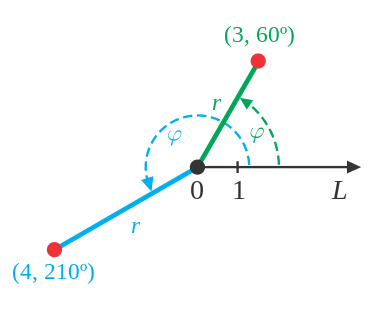
You can represent any point in this system with (distance, angle), for example, (3, 60 degree)
or generally,
: rho
: theta
Converting between polar and Cartesian coordinates
Question and Answers
In polar coordinate system, a circle equation is , a line equation is , what's the max distance for a point at that circle to the line?
the answer is 6
First, we need to convert all information from polar coordinate to Cartesian coordinate:
1. circle
so now we know the center point of that circle is (0, 4), radius of the circle is 4
2. line
we know is nothing but a line of 60 degree angle.
And we also know a general line could be represented as
And
so:
How to get the max distance?
Inner a circle, diameter is the longest line segment you can get.
A special line drawn inside a circle is called a chord. A chord can be of different lengths. The longest length of the chord is called a diameter. Two times the radius makes a diameter.
And for the distance between a point() and a line(), there's a formula for it:
So first, we need to choose a line as close a diameter as possible.
For some reason, people already known the distance between a line and circle center + the radius of that circle = the max distance for a point at that circle to the line.
so:
Thank you for reading, I love the feeling of doing this.